


Case Study Number: 6
Dam name: Clondulane and Fermoy Weirs
River name: Munster Blackwater
River extension: 168km
River surface area: 3,300km2
Built date: 150 – 200 years ago
Hydropower concession: NA (no hydropower plant)AMBER TOOLS: MesoHABSIM (D2.6), Drone Survey (D2.4)
THE NEED
The Munster Blackwater is one of Ireland’s largest rivers and famous for wild Atlantic salmon fishing. It is listed as a Special Area of Conservation (SAC) under the EU Habitats Directive for a range of habitats and species, including the diadromous species Atlantic salmon (Salmo salar L.), river lamprey (Lampetra fluviatilis L.), sea lamprey (Petromyzon marinus L.) and Twaite shad (Alosa falllax Lacepéde)). The main river has two weirs, large by Irish standards at approx. 2.5m head height, in the first 30 km of channel upstream of the tidal limit. The first weir (Clondulane) is approx. 25km upstream of the upper tidal limit and the second weir (In the town of Fermoy) is approximately 5km upstream of Clondulane. The first weir impounds water almost all the way up to the second weir at Fermoy. Both weirs were built to power mill wheels for agricultural actions – milling etc. over 150 – 200 years ago. Both are now derelict from that point of view. Both had fish pass structures in them – essentially for upstream-migrating salmon only.
Problems
- Obsolete structures
- River fragmentation
- Reduction in habitat
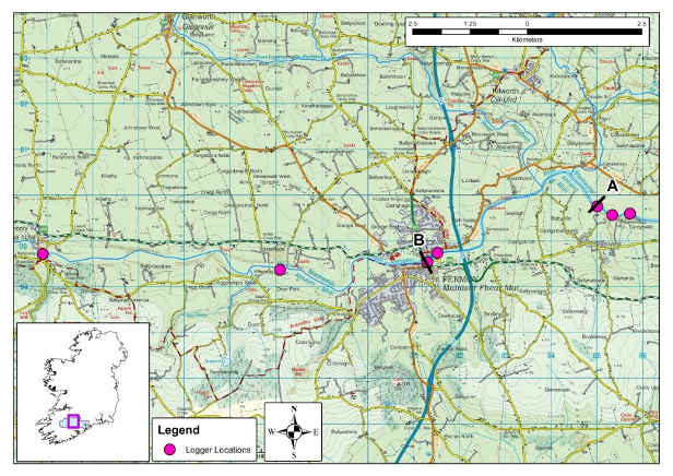
Location of revised logger locations (2019) in the Munster Blackwater, A = Clondulane weir, B = Fermoy Weir, thermal impact of linear impoundments investigation.
WHAT WE DID
AMBER investigated Fish communities in deep-water impounded riverine segments; studied European Eel in deep-water impounded riverine segments; used telemetry to investigate spatial ecology of dace and brown trout in a shared impounded river reach; carried our barrier surveys; investigated the thermal impact of linear impoundments; carried out a MesoHABSIM study and reviewed adaptive management scenarios at both Clondulane and Fermoy weirs.
Tools
- MesoHABSIM (D2.6)
- Drone Survey (D2.4)
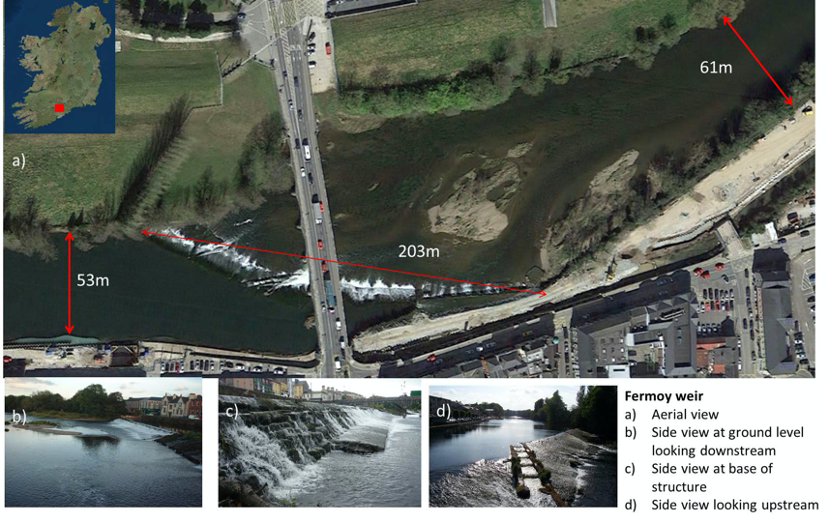
Fermoy weir measurements
NOW WHAT
The lower weir, at Clondulane, is currently the subject of Planning Permission with the local authority. The order of the Irish High Court to remove the weir remains in place . The current situation with the Fermoy weir is such that some measures are required to maintain the integrity of the overall structure. The weir structure extends through and under the existing main road crossing into the town, formerly the main National Primary route linking the cities of Dublin and Cork. Ongoing ‘unravelling’ of the weir structure may lead to hydraulic pressures on the bridge structure. Any works programme that is decided on must take account of the requirements of the SAC designation of the River Blackwater for Atlantic salmon, sea- and river lamprey and Twaite shad.
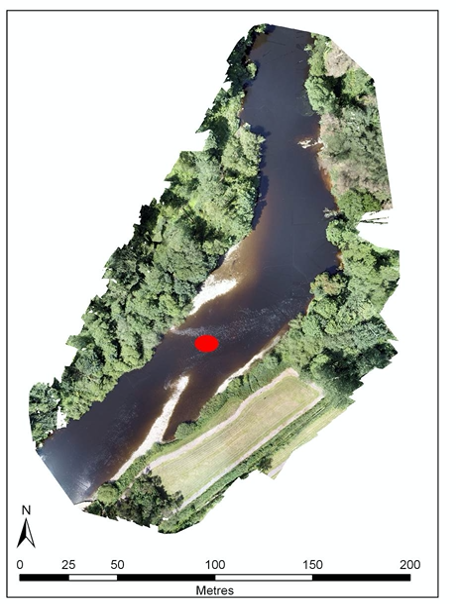
Newly formed habitat upstream of Fermoy weir (Run/Ruffle) following the breach of the weir. Red circle marks the location where 2 sea lamprey spawning redds were recorded in Summer 2019.
WHO WAS INVOLVED?
AMBER project partner IFI (Inland Fisheries Ireland), Local Authorities and Irish Government.
FURTHER READING
References
Addy, S., Cooksley, S., Dodd, N., Waylen, K., Stockan, J., Byg, A. & Holstead, K. 2016. River Restoration and Biodiversity. IUCN, New York.
Bain, M.B. & Meixler, M.M. (2008). A Target Fish Community to Guide River Restoration. River Research and Applications 24(4): 453 – 458. doi: 10.1002/rra.1065.
Bracken, F. S., Rooney, S. M., Kelly-Quinn, M., King, J. J. & Carlsson, J. 2019. Identifying spawning sites and other critical habitat in lotic systems using eDNA “snapshots”: A case study using the sea lamprey Petromyzon marinus L. Ecology and evolution, 9(1), 553-567.
Jones, J., Börger,L., Tummers, J., Jones, P., Lucas, M., Kerr,J., Kemp, P. et al. 2019. A comprehensive assessment of stream fragmentation in Great Britain. Science of the total environment 673: 756-762.
Parasiewicz, P. 2008a. Habitat time-series analysis to define flow-augmentation strategy for the Quinebaug River, Connecticut and Massachusetts, USA. River Research and Application 24: 439–452. doi: 10.1002/rra.1066.
Parasiewicz, P. 2008b. Application of MesoHABSIM and target fish community approaches for selecting restoration measures of the Quinebaug River, Connecticut and Massachusetts, USA. River Research and Application 24: 459–471. doi: 10.1002/rra.1064.
Woodget, A. S., Austrums, R., Maddock, I. P. & Habit, E. 2017. Drones and digital photogrammetry: from classifications to continuums for monitoring river habitat and hydromorphology. WIREs Water 2017, 4:e1222. doi: 10.1002/wat2.1222.